
Expand the size of the proposed Greenline
From "Bikeways and Trail Plan"
Go to the project
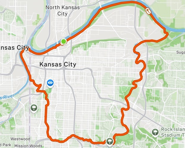
I think the city should be more ambitious about the proposed Greenline loop. What they have so far is an excellent starting point -- it makes sense to work it into the true core of the city. But one of the models for this project, Atlanta's Beltline, is more than twice as long and incorporates much more of the city's urban corridor.
There can be two different sized loops: the original 10-mile one, and then a much longer loop that pulls in key neighborhoods and natural areas that would make a ton of sense to include in a project like this. And the good news: much of the infrastructure for this kind of extension is already in place!
Here's the vision for a Greenline extension:
- Westside South. The existing two-way cycle track on SW Blvd would break off of the original Greenline and extend southwest, taking a route past Boulevard Brewing (and possibly Alma Mader Brewing and The Roasterie as well).
- Penn Valley Park. The path would turn on any of 25th, 26th, or 27th Streets veering east toward Penn Valley Park -- if on 25th or 26th, it would link with Summit and then come south to 27th. (Note: the two intersections on 27th at Summit and Southwest Tfwy may be the trickiest parts to navigate in the entire plan.) When the route reaches Penn Valley Park, it meets up with the existing sidewalk that runs along Broadway above the pond. Where Broadway and Penn Valley Dr split, the path would continue along the latter, working its way south to Wyandotte St, where there already exists a two-way bike track that extends down to Linwood Blvd.
- Broadway Blvd connection. From there, the goal is to simply navigate over to the brand new Broadway Blvd cycle track -- the most straightforward way to do this is turning the sidewalk on the north side of Linwood into path for just one city block.
- West Midtown/Westport. The route then coopts the existing Broadway cycle track, which extends all the way down to Westport Rd. This is the western side of the big Greenline loop, and the idea is to extend this all the way down to the Plaza. At Westport Rd, the cycle track runs out, so there needs to be some connection between there and Mill Creek Park, which can help guide the route to the Plaza. The most obvious idea is turning the sidewalk on the east side of Broadway into a multi-use path and run that down to 43rd St, where it would then continue onto the west side of Mill Creek Park, running parallel with the park's existing paved trails.
- The Plaza. Once the route reaches the Plaza, it would continue south on Baltimore Ave one block until it meets up with Brush Creek. The plan then involves creating a new entrance ramp to the north side Brush Creek Trail at Ward Pkwy. From this point, the rest of the route would run along bodies of water and be 99% protected from cars until it re-connects to the original Greenline.
- Brush Creek. After joining the north Brush Creek Trail (which may require upgrades at certain points, such as widening parts of the path or adding some sort of barrier between the trail and the creek), the route would go all the way east where the existing trail meets the Blue River. Rather than veering south through the industrial area and then taking Colorado Ave to the Blue River Trail, there are two options here: create a new trail on the west side of the river running north toward Stadium Dr or build a bridge over the river to connect the Brush Creek Trail to the existing eastside Blue River Trail!
- Blue River. At that point, the route would run north along the Blue River until it reaches Stadium Dr. It would then continue north on brand new trail on the west side of the river. I chose the west side for a couple of reasons: 1) It offers direct access to more green space in Blue Valley Park, and 2) this trail would run all the way up to the Missouri River, where it then veers west and back toward the original Greenline, so this would avoid the need to build some kind of bridge at the confluence of the Blue River and the MO River to get across from the east side of the Blue River.
- Blue River (cont.). The other benefit of making the Blue River the east side of this loop is that it offers an opportunity for the city to more vigorously revitalize it. In addition to bolstering long overdue clean-up that is already underway, the city could also plant new tree cover along the path. This is good for shade and also helps beautify the area, as the industrial areas the river runs by don't exactly have much aesthetic appeal. There's also an opportunity here to tell the history of the Blue River with placards showing depictions of what it looked like more than a century ago and discussing how it played a role in connecting the city.
- MO River/Riverfront Park. Once the path reaches the MO River, it would then head west to meet up with the original 10-mile Greenline. This link also has a lot of upside, as it not only allows riders and pedestrians to enjoy a longer stretch of the river, but the city is also currently looking at revitalizing Riverfront Park, including possibly adding some trails. What better way to encourage people to visit the park than to bring a popular trail through it (and offer people on the trail more true green space/tree cover)?
- Original Greenline connection. Finally, this stretch of the route would run west until it connects with the existing Greenline at Current Landing.
This is no doubt an imperfect plan. Some areas will require getting creative to make connections. Some connections/upgrades may cost a pretty penny. But the city has more momentum right now than it has at any point in my life, so I say, why not take the opportunity to be bold?

